SPQU AD 2.1 To be translated
|
|
SPQU - AREQUIPA / INTL ALFREDO RODRIGUEZ BALLÓN
|
|
SPQU AD 2.2 To be translated
|
|
1
|
To be translated
|
162026S 0713415W
1265 m FM THR 28 DESPLAZADO
1265 m FM THR 28 DISPLACED
|
|
|
ARP coordinates and site at AD
|
2
|
To be translated
|
8 km al NW
8 km to the NW
|
|
|
Direction and distance from (city)
|
3
|
To be translated
|
Elev: 8400 FT (2560 M) / T: 22.6° C (Mean Low T: NIL)
|
|
|
Elevation / Reference temperature (Mean Low temperature)
|
4
|
To be translated
|
NIL
|
|
|
Geoid undulation at AD ELEV PSN
|
5
|
To be translated
|
6° W (2020) / 0°13' W
|
|
|
MAG VAR / Annual change
|
6
|
To be translated
|
AEROPUERTOS ANDINOS DEL PERÙ S.A. - AAP
Av. Aviación S/N Zamácola, Distrito de Cerro Colorado - Arequipa
Arequipa PERÚ
Tel: (054) 344834
AFS: SPQUYDYX
email: atencionalcliente@aap.com.pe
|
|
|
AD Administration, address, telephone, telefax, telex, AFS
|
7
|
To be translated
|
IFR/VFR
|
|
|
Types of traffic permitted (IFR/VFR)
|
8
|
To be translated
|
NIL
|
|
|
Remarks
|
|
SPQU AD 2.3 To be translated
|
|
1
|
To be translated
|
1100-0300 (UTC +5)
|
|
|
AD Administration
|
2
|
To be translated
|
1100-0300 (UTC +5)
|
|
|
Customs and immigration
|
3
|
To be translated
|
1100-0300 (UTC +5)
|
|
|
Health and sanitation
|
4
|
To be translated
|
1100-0300 (UTC +5)
|
|
|
AIS Briefing Office
|
5
|
To be translated
|
1100-0300 (UTC +5)
|
|
|
ATS Reporting Office (ARO)
|
6
|
To be translated
|
H24
|
|
|
MET Briefing Office
|
7
|
To be translated
|
1100-0300 (UTC +5)
|
|
|
ATS
|
8
|
To be translated
|
1130-0230 (UTC +5)
y O/R
1130-0230 (UTC +5)
|
|
|
Fuelling
|
9
|
To be translated
|
1100-0300 (UTC +5)
|
|
|
Handling
|
10
|
To be translated
|
H24
|
|
|
Security
|
11
|
To be translated
|
NIL
|
|
|
De-icing
|
12
|
To be translated
|
COM H24
|
|
|
Remarks
|
|
SPQU AD 2.4 To be translated
|
|
1
|
To be translated
|
01 Montacarga de 25 t de capacidad. 01 carreta. No se dispone de personal para manipuleo de carga.
01 Forklift of 25 t capacity. 01 CARTS. No personnel available for cargo handling.
|
|
|
Cargo-handling facilities
|
2
|
To be translated
|
To be translated: JET A1
To be translated: TURBO
Fuel: JET A1
Oil: TURBO
|
|
|
Fuel / oil types
|
3
|
To be translated
|
En plataforma. Sin restricción.
On apron. Without restriction.
|
|
|
Fuelling facilities/capacity
|
4
|
To be translated
|
NIL
|
|
|
De-icing facilities
|
5
|
To be translated
|
NIL
|
|
|
Hangar space for visiting aircraft
|
6
|
To be translated
|
Sí
Yes
|
|
|
Repair facilities for visiting aircraft
|
7
|
To be translated
|
NIL
|
|
|
Remarks
|
|
SPQU AD 2.5 To be translated
|
|
1
|
To be translated
|
En la ciudad
In the city
|
|
|
Hotels
|
2
|
To be translated
|
En el AD y la ciudad
In the AD and in the city
|
|
|
Restaurants
|
3
|
To be translated
|
Taxis desde y hacia la ciudad
Taxis from and to the city
|
|
|
Transportation
|
4
|
To be translated
|
En el aeropuerto y en la ciudad
In the airport and in the city
|
|
|
Medical facilities
|
5
|
To be translated
|
To be translated: En el AD y la ciudad
To be translated: NIL
Bank: In the AD and in the city
Post: NIL
|
|
|
Bank and Post Office
|
6
|
To be translated
|
En el AD y la ciudad
In the AD and in the city
|
|
|
Tourist Office
|
7
|
To be translated
|
NIL
|
|
|
Remarks
|
|
SPQU AD 2.6 To be translated
|
|
1
|
To be translated
|
CAT A7
|
|
|
AD category for fire fighting
|
2
|
To be translated
|
Equipo de primeros auxilios, Equipos de mercancÍas peligrosas y 02 vehÍculos
First aid equipment, Dangerous goods equipment and 02 vehicles
|
|
|
Rescue equipment
|
3
|
To be translated
|
Hasta 77 t (Empresa externa)
Up to 77 t (External company)
|
|
|
Capability for removal of disabled aircraft
|
4
|
To be translated
|
942174403/054-344834
seg.aqp@aap.com.pe
|
|
|
Remarks
|
|
SPQU AD 2.7 To be translated
|
|
1
|
To be translated
|
NIL
|
|
|
Types of clearing equipment
|
2
|
To be translated
|
NIL
|
|
|
Clearance priorities
|
3
|
To be translated
|
NIL
|
|
|
Use of material for movement area surface treatment
|
4
|
To be translated
|
NIL
|
|
|
Specially prepared winter runways
|
5
|
To be translated
|
NIL
|
|
|
Remarks
|
|
SPQU AD 2.8 To be translated
|
|
1
|
To be translated
|
APN
|
Calcestruzzo ed asfalto
Concrete and asphalt
|
PCN 43/R/B/X/T
PCN 39/F/B/X/T
|
|
|
|
Apron surface and strength
|
2
|
To be translated
|
ALFA
|
23 M
|
Asfalto
Asphalt
|
PCN 39/F/B/X/T
|
TXL BRAVO
|
23 M
|
Asfalto
Asphalt
|
PCN 39/F/B/X/T
|
TXL BRAVO 1
|
23 M
|
Asfalto
Asphalt
|
PCN 39/F/B/X/T
|
|
|
|
Taxiway width, surface and strength
|
3
|
To be translated
|
NIL
|
|
|
Altimeter checkpoint location and elevation
|
4
|
To be translated
|
NIL
|
|
|
VOR checkpoints
|
5
|
To be translated
|
NIL
|
|
|
INS checkpoints
|
6
|
To be translated
|
VOR/DME sin letrero, NO APLICABLE, situado fuera de las inmediaciones del aeropuerto con diferentes niveles de altitud.
TWY ALFA cerrada.
VOR/DME Without sign, NOT APPLICABLE, placed outside the vicinity of the airport at different altitude levels.
TWY ALFA closed.
|
|
|
Remarks
|
|
SPQU AD 2.9 To be translated
|
|
1
|
To be translated
|
Señales de guía de rodaje en todas las intersecciones entre TWY y RWY y en todos los puntos de espera. Líneas de guía en la plataforma. Guía visual de estacionamiento en los puestos de aeronaves.
Taxiing guidance signs at all intersections between TWY and RWY, and at all holding positions. Guidance lines on apron. Visual parking guidance at aircraft stands.
|
|
|
Use of aircraft stand ID signs, TWY guide lines and visual docking/parking guidance system of aircraft stands
|
2
|
To be translated
|
RWY: Designación, THR, TDZ, eje y borde de pista, según corresponda, señalados. Bordes, THR y extremo iluminados.
TWY: Puntos de espera en todas las intersecciones TWY/RWY, señalados. Bordes iluminados.
RWY: Designation, THR, TDZ, Runway centre line and Runway edge, as applicable, marked. Lighted Edges, THR and Runway end.
TWY: Holding positions at all intersections between TWY/RWY, marked. Lighted Runway edges.
|
|
|
RWY and TWY markings and LGT
|
3
|
To be translated
|
NIL
|
|
|
Stop bars and runway guard lights
|
4
|
To be translated
|
NIL
|
|
|
Other runway protection measures
|
5
|
To be translated
|
NIL
|
|
|
Remarks
|
|
SPQU AD 2.10 To be translated
|
|
To be translated / In Area 2
|
To be translated
|
To be translated
|
To be translated
|
To be translated
|
To be translated
|
To be translated
|
OBST ID / Designation
|
OBST type
|
OBST position
|
ELEV/HGT
|
Markings/
Type,
colour
|
Remarks
|
a
|
b
|
c
|
d
|
e
|
f
|
|
To be translated / In Area 3
|
To be translated
|
To be translated
|
To be translated
|
To be translated
|
To be translated
|
To be translated
|
OBST ID / Designation
|
OBST type
|
OBST position
|
ELEV/HGT
|
Markings/
Type,
colour
|
Remarks
|
a
|
b
|
c
|
d
|
e
|
f
|
|
SPQU AD 2.11 To be translated
|
|
1
|
To be translated
|
OMA
|
|
|
Associated MET Office
|
2
|
To be translated
|
1100 - 2300 (UTC + 5)
|
|
|
Hours of service
MET Office outside hours
|
3
|
To be translated
|
OMA/SPQU-SPJC
24 horas
24 hours
|
|
|
Office responsible for TAF preparation
Period of validity
|
4
|
To be translated
|
TREND (TR) Cada hora
TREND (TR) Every hour
|
|
|
Trend forecast
Interval of issuance
|
5
|
To be translated
|
Consultazione personale (P) Sí
Personal consultation (P) Yes
|
|
|
Briefing/consultation provided
|
6
|
To be translated
|
Mapas, Pronóstico, Observaciones e informes MET (Productos WAFS). ES
Maps, Forecast, Observations and MET Reports (WAFS Products).
|
|
|
Flight documentation
Language(s) used
|
7
|
To be translated
|
Mapas, Cartas, Imágenes MET de satelite e información MET Codificada.
Maps, Charts, MET Satellite Imagery and MET Encoded information.
|
|
|
Charts and other information available for briefing or consultation
|
8
|
To be translated
|
Terminal AMHS CADAS, Banco de Datos alterno OPMET, Internet.
AMHS CADAS Terminal, OPMET Alternate Data Bank, Internet.
|
|
|
Supplementary equipment available for providing information
|
9
|
To be translated
|
TWR SPQU
ARO SPQU
APP SPQU
|
|
|
ATS units provided with information
|
10
|
To be translated
|
NIL
|
|
|
Additional information (limitation of service, etc.)
|
|
SPQU AD 2.12 To be translated
|
|
To be translated
|
To be translated
|
To be translated
|
To be translated
|
To be translated
|
To be translated
|
RWY Designator
|
TRUE BRG
|
Dimension of RWY (M)
|
Strength (PCN) and surface of RWY and SWY
|
THR coordinates
RWY end coordinates
THR geoid undulation
|
THR elevation and highest elevation of TDZ of precision APP RWY
|
1
|
2
|
3
|
4
|
5
|
6
|
10
|
093.00°
|
2980 x 45
|
PCN 39/F/B/X/T
Asfalto
Asphalt
SWY: NIL
|
162023.42S
0713504.99W
END: NIL
GUND: NIL
|
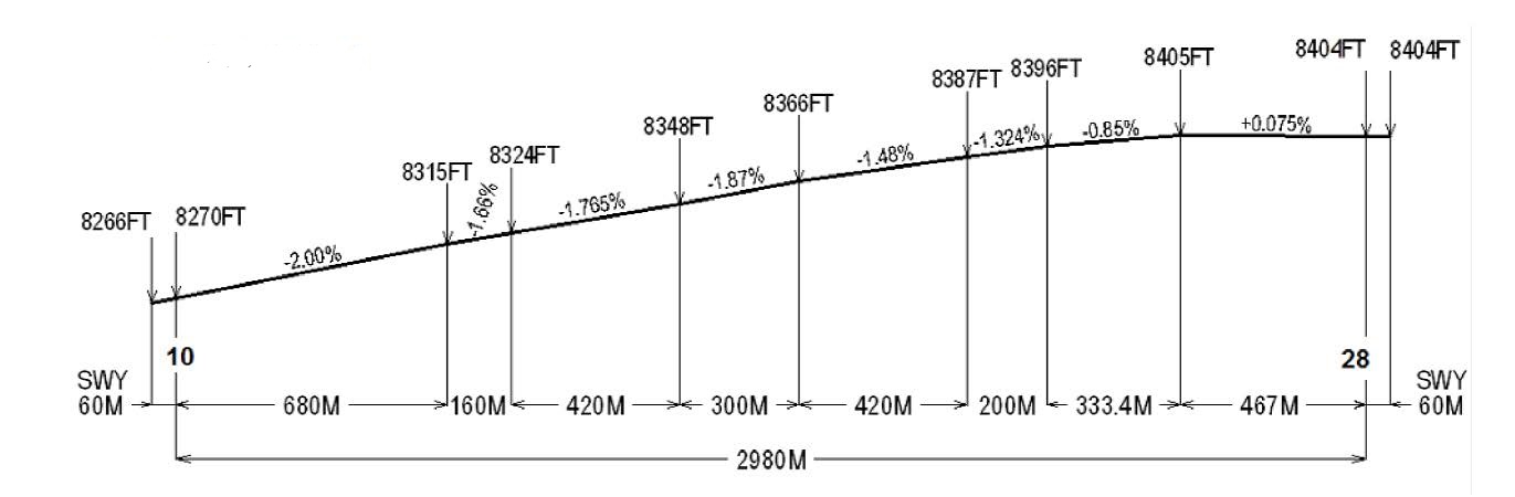
THR 8270.0 FT
TDZ: NIL
|
28
|
273.00°
|
2980 x 45
|
PCN 39/F/B/X/T
Asfalto
Asphalt
SWY: NIL
|
162028.74S
0713324.79W
END: NIL
GUND: NIL
|
THR 8400 FT
TDZ: NIL
|
|
To be translated
|
To be translated
|
To be translated
|
To be translated
|
To be translated
|
To be translated
|
To be translated
|
To be translated
|
RWY Designator
|
Slope of RWY-SWY
|
SWY dimensions (M)
|
CWY dimensions (M)
|
Strip dimensions (M)
|
RESA dimensions (M)
|
Location/
description of arresting system
|
OFZ
|
1
|
7
|
8
|
9
|
10
|
11
|
12
|
13
|
10
|
NIL
|
60 x 45
|
NIL
|
3100 x 150
|
NIL
|
NIL
|
NIL
|
28
|
NIL
|
60 x 45
|
NIL
|
3100 x 150
|
NIL
|
NIL
|
NIL
|
|
To be translated
|
To be translated
|
RWY Designator
|
Remarks
|
1
|
14
|
10
|
NIL
|
28
|
DTHR 28 = 450 m / S16 20 27.95 W 071 33 39.86
|
|
|
|
SPQU AD 2.13 To be translated
|
|
To be translated
|
TORA
(M)
|
TODA
(M)
|
ASDA
(M)
|
LDA
(M)
|
To be translated
|
RWY Designator
|
Remarks
|
1
|
2
|
3
|
4
|
5
|
6
|
10
|
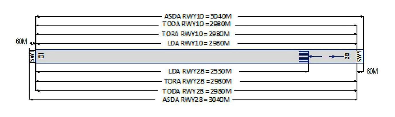
2980
|
2980
|
3040
|
2980
|
NIL
|
28
|
2980
|
2980
|
3040
|
2530
|
DTHR 450 m
|
|
|
|
SPQU AD 2.14 To be translated
|
|
To be translated
|
To be translated
|
To be translated
|
To be translated
|
To be translated
|
To be translated
|
RWY Designator
|
APCH LGT type LEN INTST
|
THR LGT colour WBAR
|
VASIS (MEHT) PAPI
|
TDZ, LGT LEN
|
RWY Centre Line LGT Length, spacing, colour, INTST
|
1
|
2
|
3
|
4
|
5
|
6
|
10
|
OTHER
CAT1
480 M
PALS
|
Verde
Green
|
PAPI
3°
38.63 FT
|
NIL
|
NIL
|
28
|
NIL
|
Verde
Green
|
PAPI
3°
60.01 FT
|
NIL
|
NIL
|
|
To be translated
|
To be translated
|
To be translated
|
To be translated
|
To be translated
|
RWY Designator
|
RWY edge LGT LEN, spacing colour INTST
|
RWY End LGT colour WBAR
|
SWY LGT LEN
colour
|
Remarks
|
1
|
7
|
8
|
9
|
10
|
10
|
2950 M, 60 M
Bianco
White
|
Rosso
Red
|
NIL
|
Luces de destello
Flashing lights
|
28
|
2950 M, 60 M
Bianco
White
|
Rosso
Red
|
NIL
|
LGT THR Desplazado 450 m
PAPI restricción de uso desde 2.5NM THR
Displaced THR LGT 450 m
PAPI use restriction from 2.5 NM THR
|
|
SPQU AD 2.15 To be translated
|
|
1
|
To be translated
|
ABN: Edificio TWR FLG W/G EV 2.5 SEC, HN e IMC
ABN: Building TWR FLG W/G EV 2.5 SEC, HN and IMC
|
|
|
ABN/IBN location, characteristics and hours of operation
|
2
|
To be translated
|
182 m del THR 10 LGTD
182 m fromTHR 10 LGTD
|
|
|
LDI location and LGT Anemometer location and LGT
|
3
|
To be translated
|
To be translated/Taxiway edge:
ALFA
|
|
|
TWY edge and centre line lighting
|
4
|
To be translated
|
SÍ 10 s
Yes 10 s
|
|
|
Secondary power supply/switch-over time
|
5
|
To be translated
|
NIL
|
|
|
Remarks
|
|
SPQU AD 2.16 To be translated
|
|
1
|
To be translated
|
NIL
|
|
|
Coordinates TLOF or THR of FATO
Geoid undulation
|
2
|
To be translated
|
NIL
|
|
|
TLOF and/or FATO elevation M/FT
|
3
|
To be translated
|
NIL
|
|
|
TLOF and FATO area dimensions, surface, strength, marking
|
4
|
To be translated
|
NIL
|
|
|
True BRG of FATO
|
5
|
To be translated
|
NIL
|
|
|
Declared distance available
|
6
|
To be translated
|
NIL
|
|
|
APP and FATO lighting
|
7
|
To be translated
|
NIL
|
|
|
Remarks
|
|
SPQU AD 2.17 To be translated
|
|
To be translated
|
To be translated
|
To be translated
|
To be translated
|
To be translated
|
To be translated
|
To be translated
|
Designation and lateral limits
|
Vertical limits
|
Airspace classification
|
ATS unit call sign Language(s)
|
Transition altitude
|
Hours of applicability
|
Remarks
|
1
|
2
|
3
|
4
|
5
|
6
|
7
|
AREQUIPA TMA
Desde 163200S 0725800W por un arco de sentido horario de 50 NM de radio con centro no ponto de coordenadas 162216S 0720801W (VOR UAS) - 160122S 0725601W - 155237S 0723226W - 154053S 0715937W - 153311S 0713808W por un arco de sentido horario de 47 NM de radio con centro no ponto de coordenadas 162021S 0713550W (VOR EQU) - 170418S 0711804W - 163200S 0714100W - 165000S 0722800W para o ponto de origem.
Area bounded by lines joining points 163200S 0725800W then along the clockwise arc of a circle of 50 NM radius centred on 162216S 0720801W (VOR UAS) to 160122S 0725601W - 155237S 0723226W - 154053S 0715937W - 153311S 0713808W then along the clockwise arc of a circle of 47 NM radius centred on 162021S 0713550W (VOR EQU) to 170418S 0711804W - 163200S 0714100W - 165000S 0722800W to point of origin.
|
|
NIL
|
AREQUIPA TORRE
Inglese, Spagnolo
English, Spanish
|
18500 FT AMSL
|
NIL
|
Espacio Aéreo A/D
|
ATZ SPQU
Circulo con centro en 162026S 0713415W con radio de 3 NM.
Circular area centered on 162026S 0713415W within a 3 NM radius.
|
|
D
|
AREQUIPA TORRE
Inglese, Spagnolo
English, Spanish
|
18500 FT AMSL
|
NIL
|
NIL
|
CTR SPQU
Circulo con centro en 162021S 0713550W (VOR EQU) con radio de 5.8 NM.
Circular area centered on 162021S 0713550W (VOR EQU) within a 5.8 NM radius.
|
|
D
|
AREQUIPA TORRE
Inglese, Spagnolo
English, Spanish
|
18500 FT AMSL
|
NIL
|
Espacio aéreo semicircular, hacia el sur, con un radio de 5.8 NM con centro en el VOR/DME EQU (16°20’21.05”S-071°35’49.76”W) y unida con una línea (ubicada 1 NM al norte del eje de la pista 10/28 y su prolongación) en los puntos 16°19’01.89”S - 071°41’42.01”W y 16°19’39.77”S - 071°29’50.59”W.
|
|
SPQU AD 2.18 To be translated
|
|
To be translated
|
To be translated
|
To be translated
|
To be translated
|
To be translated
|
To be translated
|
To be translated
|
Service
designation
|
Callsign
|
Frequency
|
SATVOICE
|
Logon address
|
Hours of operation
|
Remarks
|
1
|
2
|
3
|
4
|
5
|
6
|
7
|
ATIS SPQU
|
AEROPUERTO AREQUIPA
|
130.900 MHZ
|
NIL
|
NIL
|
H24
|
NIL
|
EMERGENCIA
|
EMERGENCIA
|
121.500 MHZ
|
NIL
|
NIL
|
H24
|
NIL
|
SMC SPQU
|
AREQUIPA SUPERFICIE
|
121.900 MHZ
|
NIL
|
NIL
|
H24
|
NIL
|
TWR
|
AREQUIPA TORRE
|
118.700 MHZ
|
NIL
|
NIL
|
H24
|
ALTERNA 118.2 MHz
|
|
SPQU AD 2.19 To be translated
|
|
To be translated
|
To be translated
|
To be translated
|
To be translated
|
To be translated
|
To be translated
|
To be translated
|
To be translated
|
Type of aid
MAG VAR
CAT of ILS/MLS
DECL
|
ID
|
Frequency
|
Hours of operation
|
Site of transmitting antenna coordinates
|
Elevation of DME transmitting antenna
|
Service
volume
radius
from GBAS
reference
Point
|
Remarks
|
1
|
2
|
3
|
4
|
5
|
6
|
7
|
8
|
LOC 10
(06° W)
ILS CAT I
|
IARB
|
109.700 MHZ
|
H24
|
162029.2S
0713316.3W
|
NIL
|
NIL
|
NIL
|
GP 10
(06° W)
ILS
|
IARB
|
333.200 MHZ
|
H24
|
162027.4S
0713457.4W
|
NIL
|
NIL
|
NIL
|
DME 10
(06° W)
ILS CAT I
|
IARB
|
CH 34X
|
H24
|
162027.4S
0713457.4W
|
NIL
|
NIL
|
NIL
|
VOR
(05° W)
|
UAS
|
113.500 MHZ
|
H24
|
162216.3S
0720801.1W
|
NIL
|
NIL
|
VAR 5° W 2020
|
VOR/DME
(06° W)
|
EQU
|
113.700 MHZ
CH 84X
|
H24
|
162021.1S
0713549.8W
|
39 FT
|
NIL
|
NIL
|
|
SPQU AD 2.20 To be translated
|
|
1 Reglamento del Aeropuerto
|
En el aeródromo de Arequipa se aplican varios reglamentos locales. Los reglamentos están recopilados en un manual que se puede consultar en la oficina de la Jefatura del aeropuerto. Entre otros asuntos este manual contiene:
-
el significado de las marcas y señales;
-
información acerca de los puestos de estacionamiento de aeronaves, que incluye los sistemas de guía visual para el atraque;
-
información acerca del rodaje desde los puestos de estacionamiento de aeronaves, incluso la autorización de rodaje;
-
limitaciones para las operaciones de aeronaves grandes, incluso limitaciones en el uso de su propia energía para el rodaje;
-
las operaciones de helicópteros;
-
la asistencia de señaladores en tierra y para el remolque;
-
el uso de potencia de motores superior a la potencia de régimen de marcha lenta;
-
el arranque del motor y uso del APU;
-
el derrame de combustible; y
-
las precauciones durante condiciones meteorológicas extremas.
Puede obtenerse asistencia de señaleros en tierra y más información sobre los reglamentos solicitándolas a la TWR o al control de movimiento en la superficie (SMC). Cuando un reglamento local es importante para la operación segura de las aeronaves sobre la plataforma, TWR o SMC proporcionarán la información a cada aeronave.Puede obtenerse los Reglamentos locales solicitándolos por escrito a:
Aeropuertos Andinos del Perú S.A. Av. Aviación S/N Zamácola - Cerro Colorado Arequipa - PERÚ
|
2 Rodaje hacia y desde los puestos de estacionamiento
|
2.1 AAP S.A. asignará a través de la TWR un número de puesto de estacionamiento a las aeronaves que llegan.
2.2 Los vuelos que salen deberán comunicarse con TWR para obtener autorización del ATC antes de comenzar el rodaje. Las aeronaves que salen obtendrán autorización para hacer arrancar los motores, remolques de retroceso e instrucciones sobre el rodaje desde la plataforma, en la frecuencia 118.7 MHz.
|
3 Zona de estacionamiento para aeronaves pequeñas (Aviación General)
|
3.1 Las aeronaves de aviación general serán guiadas por señaleros en tierra hasta la zona de estacionamiento para aeronaves pequeñas.
|
4 Zona de estacionamiento para Helicópteros
|
4.1 No se dispone de zona de estacionamiento exclusiva para helicópteros.
|
5 Plataforma - Rodaje en condición de invierno
|
|
|
|
|
|
|
7 Vuelos de Escuela e Instrucción - Vuelos de Ensayo Técnico- Uso de las pistas
|
7.1 Los vuelos de instrucción y de ensayo técnico, se realizarán con autorización de la DGAC.
|
8 Tránsito de Helicópteros - Limitaciones
|
Sin limitaciones, seguir instrucciones del ATS.
|
9 Retiro de Aeronaves Inutilizadas de las pistas
|
En caso de que una aeronave resulte inutilizada sobre una pista, es obligación del propietario o del usuario de dicha aeronave ocuparse de que sea retirada lo antes posible. Si el propietario no retira lo antes posible de la pista una aeronave inutilizada, ésta será retirada por las autoridades del aeródromo a expensas del propietario o del usuario.
|
10 Mínimos de Despegue IFR
|
Los mínimos de despegue IFR son regulados por la RAP 91.370.
Los operadores deben cumplir con la RAP 91.600 para los aeródromos de alternativa.
|
SPQU AD 2.21 To be translated
|
|
1 Procedimiento de atenuación de ruido
|
|
|
SPQU AD 2.22 To be translated
|
|
1 Procedimientos para los vuelos IFR dentro de la TMA
|
Los procedimientos de vuelo por instrumentos (SID, STAR, aproximación, espera, etc) no deben ser modificados. Los rumbos de alejamiento, acercamiento, mínimos de descenso, etc., han sido calculados teniendo en cuenta la topografía circundante, por tanto, cualquier variación en ellos podría reducir el margen de protección contra obstáculos del tramo correspondiente, acercando peligrosamente la aeronave a los obstáculos.
Debido a la cercanía de terreno elevado al norte y este del aeródromo, no se deberá circular por el norte del aeródromo, asimismo, por estas mismas razones, no se deberá circular en horario nocturno.
|
2 Falla de Comunicaciones
|
En caso de falla de comunicaciones, el piloto actuará de conformidad con los procedimientos para falla de comunicaciones expuestos en el Anexo 2 de OACI.
|
3 Procedimientos para los vuelos VFR dentro de la TMA
|
Siempre que lo permitan las condiciones del tránsito, se dará autorización ATC para los vuelos VFR en las condiciones que se describen a continuación:
-
Se presentará un plan de vuelo para solicitar autorización ATC, que contenga los puntos 7 a 18 y donde se indique el propósito del vuelo.
-
Solo es posible apartarse de la autorización ATC cuando se haya obtenido permiso previo.
-
El vuelo se efectuará con referencia visual vertical a tierra.
-
Se mantendrá comunicación de radio bi-direccional en la frecuencia 118.7 MHz.
|
4 Procedimientos para los vuelos VFR dentro de la CTR
|
-
Se llenará un plan de vuelo, para el vuelo correspondiente.
-
La autorización ATC se obtendrá de la Torre de Control.
-
Solo es posible apartarse de la autorización ATC cuando se haya obtenido el permiso previo.
-
El vuelo se efectuará con referencia visual vertical a tierra.
Se establecerá comunicación de radio bi-direccional en la frecuencia 118.7 MHz antes de que el vuelo penetre a la zona de control.
|
SPQU AD 2.23 To be translated
|
|
1 Restricciones locales de Vuelo
|
Los operadores de vuelos no regulares, civiles o militares deben coordinar sus planes de vuelo 24 horas antes de la hora estimada (ETD) con el administrador del aeródromo AAP vía e-mail a: aqpcoordinacionesfpl@aap.com.pe
|
SPQU AD 2.24 To be translated
|
|
|
CARTAS /
CHARTS
|
NOMBRE /
NAME
|
PÁGINA /
PAGES
|
|
1 Plano de Aeródromo - OACI
|
|
AD 2 SPQU 13 |
|
2 Carta de Área - OACI (rutas de salidas y llegadas)
|
|
AD 2 SPQU 15 |
|
3 Descripción de Carta de Área - OACI (rutas de salidas y llegadas)
|
|
AD 2 SPQU 15-1 |
|
4 Carta de Salida Normalizada - Vuelo por Instrumentos (SID) - OACI
|
RWY 28 KOLKA 3F |
AD 2 SPQU 17 |
|
RWY 28 GAVAR 2F
|
AD 2 SPQU 17A |
|
RWY 28 TONOS 3F
|
AD 2 SPQU 17B |
|
RWY 28 SIMEL 1F - KOLKA 3G
|
AD 2 SPQU 17C |
|
RWY 28 SIMEL 1G
|
AD 2 SPQU 17D |
|
5 Carta de Llegada Normalizada - Vuelo por Instrumentos (STAR) - OACI
|
RWY 10 TOROK 1 - KOLKA 3A - ASUPA1A |
AD 2 SPQU 19 |
|
RWY 10 TONOS 3A - GAVAR 2A
|
AD 2 SPQU 19A |
|
RWY 10 RNAV ASUPA 1B
|
AD 2 SPQU 19B |
|
6 Carta de Aproximación por Instrumentos (IAC) - OACI
|
ILS RWY 10 |
AD 2 SPQU 21 |
|
VOR RWY 10
|
AD 2 SPQU 21A |
|
7 Carta de Aproximación Visual - OACI
|
|
AD 2 SPQU 23 |
|
SPQU AD 2.25 To be translated
|
|
|
|